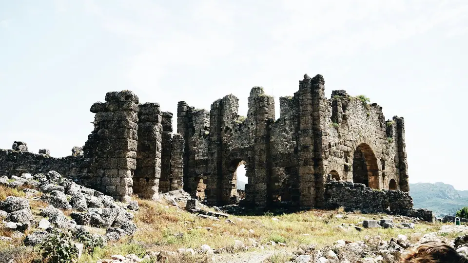
Photo by T. Selin Erkan on Unsplash
Day Trips from Antalya
Explore Roman theatres, mountain ruins, coastal national parks, and limestone waterfalls on day excursions from Antalya.
Day trips from Antalya link classical Pamphylian and Lycian cities with rugged mountain national parks and cascading karst waterfalls across the wider province.
Roman Monuments at Aspendos
Aspendos sits 40 km east of Antalya beside the Köprüçay River, which bore the name Eurymedon in antiquity. The historic settlement comprises two separate topographical sectors designated as the Lower and Upper Cities. The celebrated theatre stands in the Lower City. The architect Zenon designed this grand structure between 138 and 164 AD, providing tiered seating for 15,000 spectators.
This monument survives as one of the most intact Roman performance venues anywhere in the world. In 1959, the ancient arena hosted Turkey's first theatre festival. It still accommodates public performances, hosting the Aspendos Opera and Ballet Festival every summer as well as live music concerts. Seljuk builders later decorated parts of the building with ornate tiles. Travellers can examine several preserved Seljuk tiles in the Antalya Ethnography Museum.
A footpath climbs from the lower ground into the Upper City. This acropolis zone contains an ancient agora, an odeon, and a monumental fountain measuring 35 metres long and 15 metres high. A 100-metre-long basilica also remains standing on the plateau. A stone aqueduct stretches for one kilometre across the valley floor. It once conveyed clean drinking water to the acropolis from mountain springs situated 25 km northwest of the settlement.
The archaeological site welcomes visitors every day. An official audio guide service operates on site to assist visitors navigating the ruins. You can coordinate your journey with other historical sites featured in our Antalya 3-day itinerary.
The Colonnaded Streets of Ancient Perge
Perge lies 20 km east of Antalya along the arterial highway leading towards the coastal city of Alanya. Due to the cultural value of its unearthed architecture, the site holds a place on the tentative roster for World Heritage recognition. Historical and linguistic documentation confirms human occupation reaching back into the Bronze Age. The name of Perge appears explicitly in a diplomatic treaty from the reign of the Hittite monarch Tudhaliya IV, who ruled between 1237 and 1209 BC.
Two imposing stone towers greet arrivals at the city entrance, dating back to the 3rd century BC. Beyond these defensive fortifications runs a paved thoroughfare roughly 500 metres long leading towards a monumental fountain. This stone road serves as the official starting point of St Paul's Way, one of the most prominent trekking paths in Turkey. During his apostolic journeys, St Paul visited Perge on more than one occasion.
Perge contains an enormous athletic stadion capable of seating up to 12,000 people. This arena represents the second-largest surviving structure of its kind across Anatolia. The ancient theatre of Perge remains temporarily closed to the public while teams carry out restoration work. Archaeologists have recovered numerous extraordinary statues from the surrounding ruins. The Antalya Museum displays these recovered figures within its renowned collection of Roman sculptures.
The Mountain Bastion of Termessos
Termessos sits 35 km northwest of Antalya, reached along the highway towards Denizli and Korkuteli. Drivers turn off at the 24th kilometre onto a dedicated mountain road leading into Mount Güllük Termessos National Park. The city occupies an elevated valley set between the rugged crags of Solymos Mountain, which is also known locally as Güllük Mountain.
The Solyms founded the settlement within the southwestern Pisidian district of Milyas. They descended from the Luwians, who were among the oldest peoples of Anatolia. Alexander the Great besieged the mountain stronghold in 333 BC. The inhabitants defended their elevated ramparts vigorously and refused to surrender, creating one of the rare locations that Alexander failed to conquer.
Amyntas of Galatia ruled Termessos along with neighbouring Pisidian cities between 36 and 25 BC. A grand Doric stoa standing west of the public agora was built during the reign of Attalos II between 159 and 138 BC. The ruins lie scattered across dense pine forest, including an intact rock-hewn theatre. The Antalya Museum displays the remarkable carved Dog Sarcophagus from Termessos in its designated Sarcophagi Hall.
Harbours and Forest Paths at Phaselis
Phaselis is located roughly 70 km southwest of Antalya, reached by driving along a scenic coastal highway through the pine-covered foothills. Settlers from Rhodes founded the city as a maritime trading port in the 7th century BCE. The coastal topography allowed ancient engineers to establish three natural harbours that sheltered merchant vessels from prevailing Mediterranean winds.
The preserved ruins stand directly adjacent to turquoise bays shaded by mature coastal trees. Travellers can examine the surviving stone arches of a Roman aqueduct running along the forest paths. Paved avenues connect the sheltered anchorages with remnants of public baths, storerooms, and city civic spaces. To prepare for excursions that combine rough archaeological terrain with coastal swims, consult our guide on what to wear in Antalya.
The Overgrown Ruins and Coast of Olympos
Olympos is located 80 km southwest of Antalya in Yazır Mahallesi, within the boundaries of the Kumluca municipal district. The settlement forms part of Olympos Beydağları National Park. Settlers established Olympos in the 3rd century BC, and it quickly grew into a prosperous maritime hub. It commanded three votes in the Lycian League Council, reflecting its regional political importance.
Due to its secluded position along the coast, Olympos became an active stronghold for Mediterranean pirates during the 1st century BC. Roman commander Servilius Isauricus captured the outpost in 78 BC, converting it into a formal Roman municipal city. Today, dense wild vegetation covers much of the site, concealing an acropolis on an elevated hill, defensive city walls, bridge remnants, and an overgrown theatre.
The city river was historically channelled into an artificial stone canal that empties directly onto a pebbled Mediterranean beach. This coastal shore provides a natural spawning area for Caretta carettas. Nearby on the mountain slopes burns the eternal Chimera fire. This natural gas phenomenon has released continuous flames for thousands of years, historically serving as a navigational beacon for ancient mariners.
Upper and Lower Düden Waterfalls
The Düden waterfalls demonstrate the dramatic limestone drainage systems that shape the hydrology of Antalya province. Water disappears underground at Bıyıklı Düdeni and flows for roughly fourteen kilometres through subterranean channels. It surfaces briefly at the Varsak depression, flows a short distance, and plunges back underground. After two kilometres of underground flow, the stream reappears on the surface at Düdenbaşı.
Upper Düden Waterfall sits in Düdenbaşı Mahallesi on 21. Cadde within the northern Kepez district. The site is known variously in historical records as Düdenbaşı Waterfall or Alexander Waterfall. The torrent cascading down the travertine rock face originates from the Kepez hydroelectric facility. Local public buses and municipal minibuses connect city neighbourhoods directly with the entrance gates.
Below Düdenbaşı, the stream splits into two major waterways at the Koyunlar regulator. Nine kilometres past this distribution point, Lower Düden Waterfall reaches the Mediterranean coastline east of the city centre. Here, the river plunges approximately forty metres over a towering travertine cliff directly into open seawater.
Transport Hubs and Regional Travel Rules
Antalya Intercity Bus Terminal lies 4 km north of central Antalya, operating as an essential public transit hub for the regional coastline. The AntRay tram line links Antalya Airport, the central city districts, the bus terminal, and Fatih. At the airport, Terminal 1 and Terminal 2 stand 2.5 km apart, requiring roughly five minutes by road.
Motorists driving across Turkey need a 1968 international driving permit or a UK driving licence officially notarised in Turkish. Drivers and passengers using mopeds must wear approved safety helmets. Turkish law requires all individuals to carry official photo ID at all times. Keep your passport or official residency card secure in your day bag.
Smoking remains prohibited on public transport and inside all enclosed workplaces and public premises. Taking ancient items out of Turkey or buying historical relics is forbidden by law, bringing potential custodial terms between 5 and 12 years. If lifeguards raise a red flag along the coast, bathers are prohibited from swimming.
Where it is
- 1Antalya
- Antalya International Airport (AYT) · about 8 km from Antalya in a straight line
- Directions in Google Maps
Stations and taxi ranks: OpenStreetMap. Airports: OurAirports. Distances are in a straight line.
Traveller tips
Real advice from people who have been to Antalya. Every tip is read by our team before it goes live.
No tips yet. Been here? Yours could be the first.
Thank you! Your tip will appear here after a quick review.
More in Antalya
Continue exploring Antalya with related neighbourhood, food, and planning guides