
















Bab al-Siq & The Siq Walk: Djinn Blocks, Obelisk Tomb, Dam & Nabataean Water Channels
Walk the 800-metre Bab al-Siq and 1.2-kilometre Siq canyon in Petra with our guide to the Djinn Blocks, Obelisk Tomb, Nabataean flood dam, terracotta water pipes, and votive niches.
Every journey into the ancient city from the main Wadi Musa gate begins along a two-part approach corridor measuring 2 kilometres in total length. The open 800-metre gravel valley of Bab al-Siq (BAHB al-SEEK, "Gateway to the Siq") followed by the dramatic 1.2-kilometre Siq (as-Siq, "The Shaft"). Most hurried visitors rush down this approach with their eyes fixed ahead, waiting for the first glimpse of the Treasury. Doing so misses the very monuments and hydraulic engineering works that explain how the Nabataean Kingdom survived in the desert. Below is a chronological landmark-by-landmark field guide from the Visitor Center turnstiles to the mouth of the Treasury plaza, including how to bypass the horse touts at the gate.
Bab al-Siq (0 to 800 metres): Pedestrian lane rules, Djinn Blocks, and the Obelisk Tomb
Immediately after scanning your validated ticket or Jordan Pass at the Visitor Center turnstiles, the path splits into two parallel tracks descending gently westward from 1,080 metres to 1,040 metres elevation. On the left runs the wide gravel lane used by horses and official PDTRA electric club cars. On the right runs a raised, stone-edged pedestrian walkway separated by a low wall. Stay on the right-hand pedestrian path and decline the handlers offering the "free ticket horse ride" to avoid the aggressive tipping dispute at the dam barrier. Along this 800-metre outer stretch stand two major early Nabataean funerary ensembles:
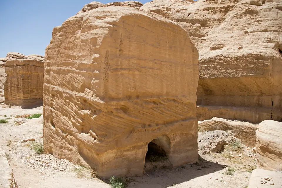
- The Three Djinn Blocks (Sahrij, 300 metres from the gate). Rising on the right side of the path are three freestanding, four-sided monolithic towers hewn directly out of the pale Disi sandstone bedrock in the first century BCE. Later Bedouin folklore named them Sahrij or "Djinn Blocks", attributing their creation to desert spirits. Archaeologists identify them as monumental tower tombs and sacred protective stelae guarding the eastern water source of the city, crowned with stepped Assyrian-style crenellations.
- The Obelisk Tomb and Bab al-Siq Triclinium (550 metres from the gate). Directly opposite the path on the left cliff face stands one of Petra's most revealing architectural hybrids. Nabataean masons carved it during the reigns of King Obodas III (30 to 9 BCE) and King Aretas IV (9 BCE to 40 CE). The upper storey is the Obelisk Tomb. Here four 7-metre-high rock-cut pyramids (nefesh, symbolic memorials for the souls of the dead) stand in a row. They flank a central niche containing a weathered relief figure in a Roman-style toga, commemorating the five burials inside. Directly beneath it, carved into the same cliff face, sits the Bab al-Siq Triclinium. A classical Doric-columned facade opening into a rock-cut banquet hall lined with three stone benches (klinai) where relatives held annual commemorative feasts (marzeah) in honour of the deceased.
The Nabataean flood dam and the 88-metre Wadi al-Mudhlim diversion tunnel
At the 800-metre mark, the open valley of Bab al-Siq ends abruptly against a sheer vertical barrier of reddish-brown Umm Ishrin sandstone. Here you cross an elevated modern concrete and stone bridge spanning the Nabataean Flood-Diversion Dam. As explained in our wadi flash-flood safety guide, winter storms over Upper Wadi Musa naturally drain straight toward the narrow throat of the Siq. To prevent flash floods from inundating their sacred entrance, first-century BCE Nabataean engineers sealed the mouth of the Siq with a heavy masonry dam. They then cut an 88-metre-long diversion tunnel through solid rock on the northern cliff face. That tunnel channels storm run-off north into the side gorge of Wadi al-Mudhlim and onward via Wadi Mataha to rejoin the central basin downstream. Rebuilt in 1964 after the tragic 1963 flood and reinforced by PDTRA with modern radar sirens, the dam marks the boundary where horse rides must stop.
Geological and hydraulic engineering inside the 1.2-kilometre Siq
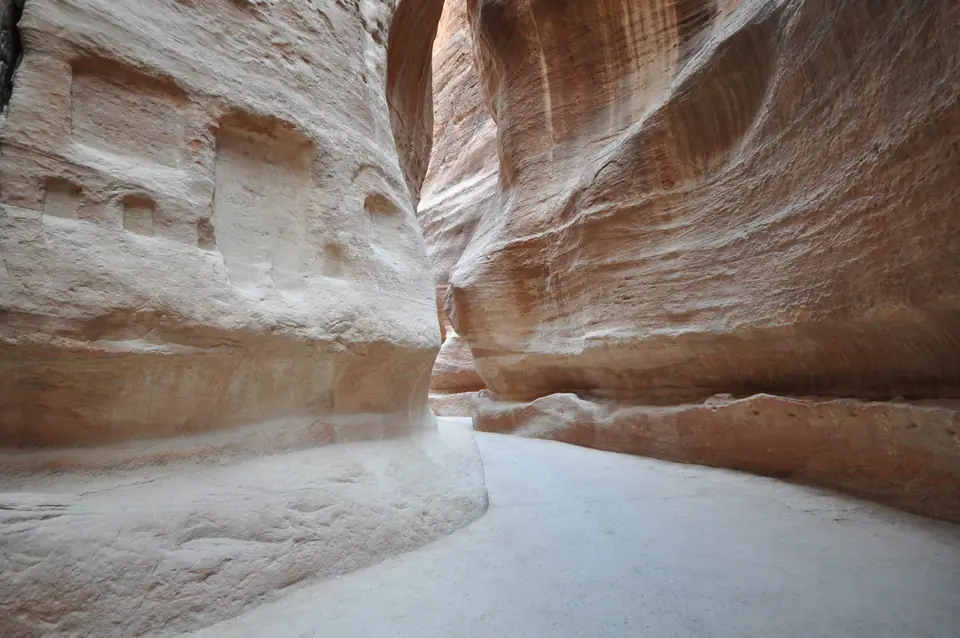
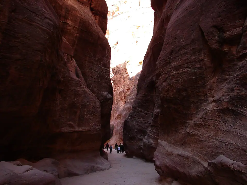
Stepping past the dam, you pass beneath the stone springings of a collapsed Nabataean Monumental Arch that once spanned the canyon entrance high overhead. Beyond those abutment niches begins the 1.2-kilometre Siq. Unlike ordinary river canyons carved purely by water erosion, the Siq is a deep tectonic fissure. Seismic forces split the sandstone mountain massif apart along a fault line, and seasonal floodwaters later smoothed the walls. Its vertical walls soar 80 to 180 metres (260 to 590 feet) above your head. Meanwhile, the canyon floor narrows in places to just 3 metres (10 feet) across, blocking out most direct midday heat.
As you walk down the winding 50-metre vertical drop from the dam (1,040 metres) to the Treasury (990 metres), take your time. Look closely at the lower side walls and canyon floor to spot four feats of ancient engineering:
- Dual Gravity-Fed Water Channels (Left and Right Walls). Running along both sides of the Siq at waist height are continuous rock-cut water channels. Nabataean hydraulic engineers built them to carry fresh spring water from Ain Musa seven kilometres upstream at a 1-to-2-percent downhill gradient. On the left (southern) wall runs an open stone trough originally capped with flat stone slabs and lined with waterproof lime-pozzolana mortar, interspersed with small settling basins designed to trap silt and slow water pressure. On the right (northern) wall runs a pressurized channel fitted with interlocking wheel-thrown terracotta ceramic pipes (samples of which are displayed at the Petra Museum).
- Crowned Roman Limestone Paving: Across long stretches of the Siq floor survive the massive, cambered limestone flagstones laid down after the first-century CE flood-control reconstruction and the 106 CE Roman annexation. Wear the lug-soled shoes recommended in our Petra footwear guide, as two millennia of footsteps have polished the stone slabs smooth.
- Sacred Betyl Votive Niches. Carved into the canyon walls are dozens of rectangular shrines holding abstract stone god-blocks called betyls (bayt-il, "House of God"). Before adopting Hellenistic human statues, the Nabataeans worshipped their chief mountain god Dushara and goddess Al-Uzza in aniconic geometric block form. Passing caravan merchants paused at these niches to burn frankincense and offer prayers for safe passage.
- The Sculpted Camel Caravan Relief (Midway Down the Siq). Approximately halfway through the canyon on the left wall, just above a preserved section of Roman road, look for a life-sized high-relief carving excavated in 1997. A robed Nabataean drover leading a string of four dromedary camels whose stone hooves are still visible in the sandstone. The carving immortalises the incense trade that financed Al-Khazneh and the Royal Tombs just ahead.
Walking etiquette, carriage safety, and photography inside the Siq
Because the 1.2-kilometre Siq narrows to just 3 metres wide in its deepest bends, sharing the canyon floor safely requires constant situational awareness. Official PDTRA electric club cars and occasional horse carriages travel both down and up the gorge throughout the day. Listen for the echo of hooves or the warning horn of approaching electric buggies reverberating off the sandstone walls. Whenever a vehicle approaches, step onto the raised stone kerbs beside the Nabataean water channels rather than standing in the middle of the cambered Roman paving stones. For photography, carry a wide-angle lens (16mm to 24mm full-frame equivalent) to capture the towering 80-to-180-metre cliffs curving overhead. Stop for photos only in the wider bays near the sacred betyl niches so you never block the narrowest bottlenecks of the slot canyon.
Look up at the vertical cliff walls inside the middle third of the Siq to spot the natural desert vegetation clinging to high rock crevices. Wild fig trees, caper bushes, and pink-flowering oleanders root directly inside shaded sandstone fractures where winter rainwater seeps through the porous rock. These high-level plants served as living markers for Nabataean hydraulic scouts searching for natural water seeps two thousand years ago. Near the canyon floor, notice how iron and manganese minerals dissolved in ancient groundwater have stained the pale Ordovician and Cambrian sandstone into swirling bands of terracotta red, mustard yellow, violet, and cream.
Returning up the Siq at the end of the afternoon offers a completely different visual perspective from your morning walk down. Walking east from the Treasury back toward the flood dam lets you spot elevated votive niches, Greek and Nabataean quarry marks, and rock-cut water settling tanks that were hidden behind rock bends on your way in. Allow 30 to 40 minutes for the gentle 50-metre uphill walk from Al-Khazneh to the dam bridge, plus another 15 minutes along Bab al-Siq to reach the Visitor Center gate.
Check the sky before entering the dam bridge between November and April. If rangers sound the flood warning sirens, follow the marked emergency stone stairs up to the raised safety ledges immediately.
Where it is
- 1Bab al-Siq & The Siq Walk
- Ramon International Airport (ETM) · about 79 km from here in a straight line
- Directions in Google Maps
Traveller tips
Real advice from people who have been to Petra. Every tip is read by our team before it goes live.
No tips yet. Been here? Yours could be the first.
Thank you! Your tip will appear here after a quick review.
More in Petra
Continue exploring Petra with related neighbourhood, food, and planning guides

What to Eat in Petra & Wadi Musa: Mansaf with Jameed, Maqluba, Zarb, Kunafa & Sage Tea
Petra, Jordan
Petra Orientation: Wadi Musa Layout, Main Trail Spine, Jordan Pass Rules & Field Traps
Petra, Jordan
Best Things to Do in Petra: The Siq, Treasury, Monastery, High Place & Little Petra
Petra, Jordan
How to Get to Petra: Amman (AMM) & Aqaba (AQJ) Airports, JETT Buses, Highways & Local Shuttles
Petra, Jordan