Preikestolen (Pulpit Rock) Hike and Lysefjorden Cruises
Hike the 3.8 km Sherpa-upgraded granite trail to the 604-metre Preikestolen cliff plateau or sail the 42-kilometre trench of Lysefjorden.
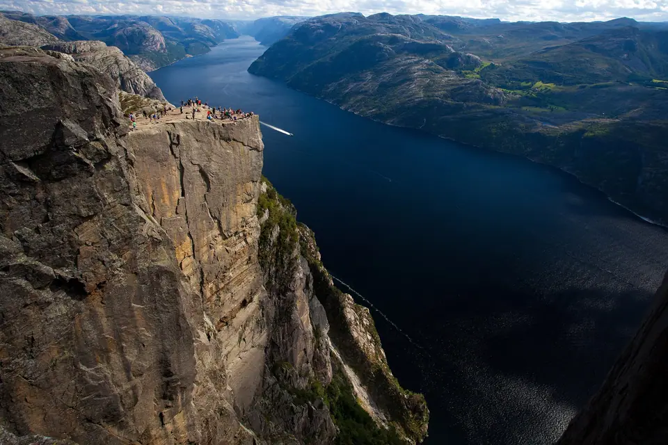
Twenty-five kilometres east of Stavanger in Strand Municipality, Preikestolen (Pulpit Rock), known locally in older times as Hyvlatonnå ('the woodworker's plane tooth'), rises 604 metres vertically above the north shore of Lysefjorden. Formed around 10,000 years ago at the end of the Last Glacial Period when frost wedging fractured the granite blocks along the retreating glacier edge, the cliff terminates in a nearly flat square plateau measuring approximately 25 by 25 metres. First photographed from above in 1896 by Thomas Peter Randulff after Captain Hana on the steamer Oscar II remarked that the overhang resembled a pulpit, the cliff was promoted for trekking around 1900 by Stavanger Turistforening (STF), which opened Prekestolhytta at the trailhead in 1949 (connected by road in 1961) and added Preikestolen Fjellstue in 2004. Around 300,000 hikers visited the plateau in 2024.
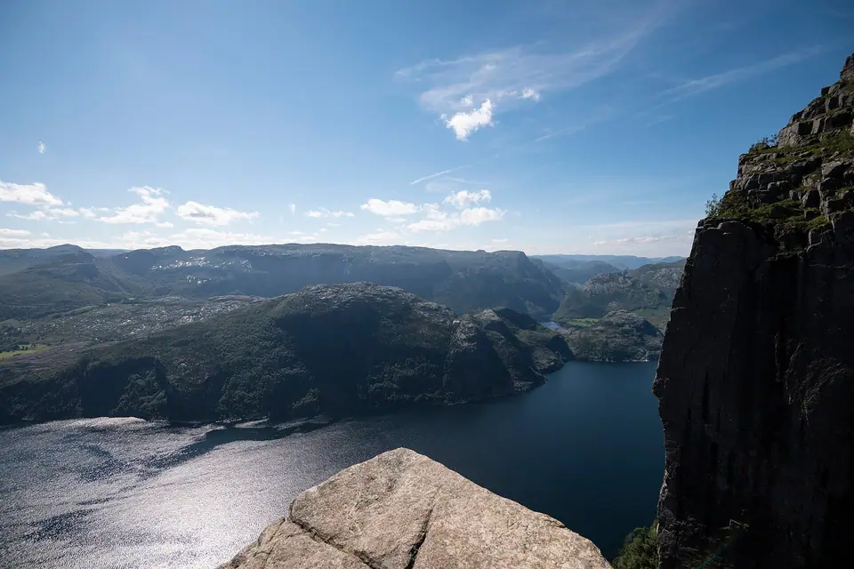
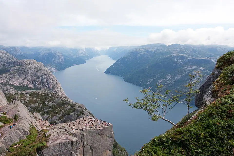
Looking down from the granite shelf or gazing upward from the deck of a fjord vessel, the sheer geometry of the cliff face leaves a lasting impression. Angular vertical joints cut deep into the pale bedrock, separating the flat tabletop from the surrounding mountainside while the dark blue trench of Lysefjorden curves away toward both the coastal islands in the west and the high mountain walls in the east.
Hiking the 3.8 km National Tourist Trail
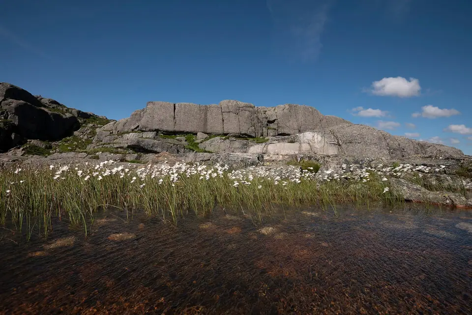
Certified in 2020 as a National Tourist Trail (Nasjonal turiststi), the main path begins at Preikestolen Fjellstue at an elevation of approximately 270 metres above sea level and climbs 334 vertical metres over 3.8 kilometres each way (around 8 kilometres round trip) to the 604-metre plateau. Between 2013 and 2016, stone-masons and Sherpas from Nepal reconstructed steep, boggy, and eroded sections of the trail with granite staircases and timber boardwalks over old railway sleepers across marshland. Walkers of average fitness require 2 to 2.5 hours each way (4 to 5 hours return), traversing three rocky ridges and passing small mountain tarns before stepping onto the unfenced cliff shelf overlooking the fjord.
Even with the stone steps in place, the route remains a genuine mountain hike rather than a paved park walk. The ascent alternates between stepped boulder gullies, pine and birch woodland, peat bogs crossed on wooden planks, and open granite slabs where painted red 'T' markers guide walkers across the bare rock toward the final narrow ledge along the cliff face.
Reaching the Trailhead via the Ryfast Tunnel
Since the April 2020 completion of the Ryfast subsea tunnel network on National Road 13, cars and direct seasonal shuttle buses cover the route from central Stavanger through the 14.3-kilometre Ryfylke Tunnel to Solbakk and Jørpeland in approximately 40 minutes, replacing the older Stavanger to Tau ferry (though the southern Lauvvik to Oanes ferry across Høgsfjorden remains an alternative).
At the base of the trail around Preikestolen Fjellstue and Refsvatnet lake, visitors find parking areas, rest facilities, equipment rental desks, and mountain lodge dining rooms. Departing from central Stavanger early in the morning allows hikers to reach the trailhead before the mid-morning coach arrivals and enjoy quieter paths along the upper granite ledges.
Seasonal Trail Conditions and Unfenced Cliff Safety
The main hiking season runs from April through October; in winter snow and ice make the steep granite slabs hazardous without guide equipment and microspikes, and Norwegian authorities keep the 604-metre cliff edge unfenced to preserve the natural landscape. Hikers should wear ankle-supporting boots with lugged rubber soles, pack windproof and waterproof shells, carry drinking water and energy snacks, and stay well back from the vertical drop when gusts sweep across the plateau.
Sailing the 42-Kilometre Lysefjorden
Travellers who prefer viewing the cliff from water level, or combining a boat passage with the hike, can board year-round sightseeing catamarans from Strandkaien in Vågen harbour or seasonal car and passenger ferries from Lauvvik and Forsand. Measuring 42 kilometres from the Lysefjord Bridge at Forsand (where the threshold is just 13 metres deep) to the eastern head at Lysebotn, Lysefjorden plunges over 400 metres deep directly beneath Preikestolen while lightly coloured granite walls admired by Victor Hugo during his 1866 visit tower more than 1,000 metres overhead, leading onward toward Flørli and Kjerag.
Combining a Fjord Cruise with the Mountain Ascent
Sightseeing catamarans slow down directly beneath the overhanging prow of Preikestolen, visits to Hengjanefossen waterfall, and sheltered coves where seals and sea eagles are frequently spotted along the rocks. Using combined boat-and-bus tickets sold during the warmer months, energetic travellers can sail through the fjord in the morning, disembark at Forsand for a connecting bus to the trailhead, hike to the plateau in the afternoon, and return to Stavanger through the Ryfylke subsea tunnel.
Along the ascent from Preikestolen Fjellstue, clear trailside signs and distance markers help walkers gauge their progress across the varied mountain terrain. After the initial climb through coastal conifers and across the stone stairs of Neverdalskaret pass, the path crosses undulating heather and bogland on timber walkways before ascending the steeper granite staircase built by Nepalese trail crews. Above the tree line, small mountain tarns sit in rocky hollows where hikers pause to rest and refill water bottles before following the cairns across the broad granite back of the mountain toward the cliff shelf.
On the plateau itself, the sheer vertical drop into Lysefjorden creates an unobstructed panorama along the length of the glacially carved trough. Across the water rise the steep granite shoulders of the southern fjord wall, while far below, the white wakes of sightseeing catamarans and ferries trace tiny arcs across the dark fjord surface. Because there are no railings or artificial barriers along the outer rock rim, visitors who feel uncomfortable near heights can sit comfortably several paces back on the wide upper granite ledges and still enjoy sweeping views of the surrounding mountains.
Down on the water, fjord cruise passengers experience the opposite perspective, looking straight up at the towering granite overhang and watching mountain streams cascade down vertical rock faces into the sea. Enclosed heated cabins with panoramic windows and open upper viewing decks allow passengers to photograph the fjord walls comfortably in spring, summer, autumn, or winter, making a boat passage an accessible alternative on days when low clouds or wet rock discourage hiking to the summit plateau.
Traveller tips
Real advice from people who have been to Preikestolen (Pulpit Rock) Hike and Lysefjorden Cruises. Every tip is read by our team before it goes live.
No tips yet. Been here? Yours could be the first.
Thank you! Your tip will appear here after a quick review.
More in Stavanger
Continue exploring Stavanger with related neighbourhood, food, and planning guides